

In the Architecture, Engineering, and Construction world, project documentation is a significant step that includes building data and details of the equipment used to achieve the outcome. The conventional surveying methods use photographs, hand drawings, or notes to document building data.
These methods can be time-consuming, tedious, difficult to follow, and include documentation errors. BIM and Laser scanning are two powerful tools that have replaced these conventional methods, ensuring project efficiency and accurate documentation.
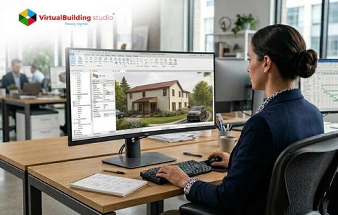
BIM services offer visualization, simulation, coordination, optimization, and drawing facilities, while 3D laser scanning ensures data authenticity and accuracy.
What is LiDAR?
Light Detection and Ranging (LiDAR) is a scanning technology used to scan the construction site with 3D lasers and cameras to document real and accurate data.
This remote sensing technology uses lasers to measure the distance between various site objects. The collected data helps in creating a BIM model with building dimensions and internal facility layout information.
As per a report by Global Market Insights, “LiDAR in the construction market was valued at USD 1.81 billion in 2021, and is anticipated to witness a growth rate of around 10% CAGR between 2022-2030”.
LiDAR technology is becoming imperative for the construction industry by enabling efficient surveying, mapping, and monitoring of construction sites, and is expected to grow steadily over the next decade.
The combination of BIM services and LiDAR scans provides a detailed representation of the existing structure and landscapes in the form of 3D models.
The LiDAR scans can be imported to Top BIM software for developing detailed as-built models, facilitating informed decision-making for architects and designers.
The current version of hand-held devices used for field documentation is equipped with the latest and most reliable LiDAR technology.
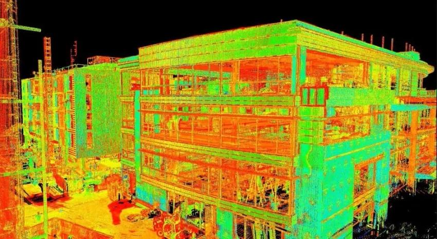
The Point Cloud scanner easily documents all the existing site conditions including space, dimensions, functions, structural system, and MEP systems.
The stakeholders can also develop a Digital Twin, which is a digital replica of the physical object, using point cloud data. Digital Twins help in stimulating the real scenarios and their results, leading to better decisions.

Benefits of Integrating LiDAR with BIM Services
BIM services have facilitated the digitization of 3D models for the construction industry and generate a detailed representation of any project. Let’s look at the benefits of integrating LiDAR scanning along with these services:
Accurate Data Analysis
The 3D scanning technology provides accurate data analysis using LIDAR. It collects project data, analyzes it, and compiles it in a 3D format easy to understand for every stakeholder.
During the Robotic Imaging process, the scanned data is converted to point cloud format that can serve as an underlay for any 3D BIM software.
Hand measuring or any other manual methods cannot keep up with the unparalleled accuracy of point clouds
Easy Data Access
The seamless collaboration facility that comes with BIM services has made it easier for the project stakeholders to access the data from anywhere. It enables them to use it for accurate analysis, suggest necessary amendments, accelerate project completion, and execute construction at lower costs.
Any team member with cloud access can navigate through the point cloud scans and study the design. Point clouds scanned using LiDAR also facilitate the clash detection process, leading to streamlined and error-free project execution.
Precise Measurements
Measurements of a project are a significant aspect of the successful execution of the space, and without a proper system in place, the completion will lead to delays and budget overruns. Integrating LiDAR technology along with BIM services eliminates human errors and measurement errors by more than 90%.
The accurate and precise measurement details of the project provide several benefits over the manual measuring methods.
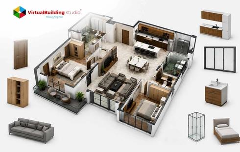
3D Model Visualization
A 3D model is a digital representation of the project that allows users to view, interact with, and analyze the project in detail.
The 3D BIM model provides a glimpse of the final product and makes it easier to identify potential issues before they affect the project costs and timeline. Scan to BIM services enable the users to scan the project using LiDAR technology and capture the space from all possible perspectives.
The collected data helps the contractors verify that their designs meet safety regulations as well as local building codes before the commencement of construction on site.
Faster Project Completion
The collaborative approach towards working allows the stakeholders to develop detailed 3D models using scan to BIM services, and communicate the strategic information to the clientele.
Enhanced coordination and communication ensure faster project completion without compromising the work quality. The data analysis stage accelerates the workflow leading to reduced waiting time while things are being finalized at later stages of development.
Limitations of Integrating LiDAR Technology
Even though BIM services and LiDAR technology are a fruitful combination for construction projects, limitations are an inevitable part of any process. One significant limitation of integrating LiDAR scanning with BIM services is the challenge of obtaining accurate data under certain circumstances.
For instance, spaces with reflective surfaces or those with complex geometries might produce inaccurate outcomes due to interference from light sources or other objects.
The time-consuming and expensive nature of the scanning process when compared to the conventional methods is another drawback that requires consideration depending on the project type and scale. Smaller businesses or organizations can be skeptical about using this technology due to the related cost factor.
Furthermore, the quality and accuracy of results depends on the quality of the used equipment and expertise of the professionals operating it.
Despite these limitations, this scanning technology is an essential tool for BIM projects due to its ability to capture project data quickly and accurately. The professionals can reap significant benefits from these services by understanding these limitations and devising ways to mitigate them.
Adoption of LiDAR Technology for AEC Projects
The adoption of scanning technology has gained momentum in the construction industry over the past few years with a considerable rise in the number of projects developed using Scan to BIM services. Building Information Modeling (BIM) is the digital representation of the functional and physical characteristics of a space and LiDAR scanning technology is a surveying method that uses a laser to capture the distance between objects.
The traditional surveying methods can be time-consuming and prone to errors, however, the combination of these two technologies can quickly document data with high levels of precision.
Enhanced visualization capabilities and detailed project views in a three-dimensional format allow for more informed decision-making throughout the construction process. The adoption of the scan to BIM services in the construction industry promises a plethora of benefits to the stakeholders, gradually enhancing project quality and streamlining the construction process.
Conclusion
It is evident from the benefits of this combination of scanning technology and BIM that it is a suitable match for modern construction projects. A comprehensive digital representation of the project with highly accurate and detailed information scanned with LiDAR works wonders for architects and designers in construction planning and efficient project execution.
The conventional approaches for quality control on construction sites are time-consuming and ineffective since they only provide data at specific times and locations.
This limits the ability of the quality-check managers to identify and manage defects at early project stages. Point cloud to BIM services is a revolutionized way of documenting project data and executing quality-driven construction.

.jpg)